Location Info
Event Details
- Date:
- Event area (map): Affpuddle Heath & Sares Wood
- Categories: Event, Organised by Wessex OC, Results
Wessex Orienteers invite you to this regional event, which is the 33rd Dorset Delight at Affpuddle Heath, one of the last remnants of Thomas Hardy’s Egdon Heath. It is now mostly forested, but includes some of the ancient woodland, where Hardy set parts of Return of the Native. It is also part of the old stomping ground of TH Lawrence (Lawrence of Arabia) who lived in nearby Clouds Hill. So, expect classic Dorset and enjoy an area that hasn’t been used for orienteering for over 20 years.
To enter, click here
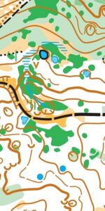
The event will take place in the most intricate part in a compact area on a ridge of heathland and forest studded with > 200 sinkholes. There will be a feel of Scandinavian forests and Slovenian sinkholes about this one. These Dorset dolines (or sinkholes) are depressions formed by subsurface solution of chalk, covered by a thin cover of sand. They take the form of small, circular or elliptical depressions that have formed when the surface sediment has collapsed into hollows formed by the dissolution of the underlying chalk. Some are so large that they are 90 metres wide and up to 12 metres deep. However, most are only 10-20m wide and 4 metres deep. Most have trees in the bottom and a covering of leaf litter, but some are active.
Results available:


Post Event Comments:
SplitsBrowser for Orange course
Planner comments
Hope you all enjoyed your day at Affpuddle. The area hasn’t been used for 25 years and Nick’s new map was really good, making it easy to plan on. The multitude of features enabled me to plan navigationally difficult courses and as the terrain in places was slow I went for shorter than normal courses with more controls. The winning times were about right but I imagine most felt they got their money’s worth. Thanks to Julie for helping with taping controls and Lyra and Tommy for helping put out flags.
Control 75 at the base of the cliffs was indeed at the bottom of the cliff. Those who approached it directly over the cliff would have found it steep and slippery. There was a gentler approach to the south, which perhaps some of you found on your return. I had intended to place this higher up so apologies for those on short green who found this an unnecessary challenge. I’d also like to apologise to those on orange for the missing two controls. As we had no white or yellow entries I automatically didn’t put them out, without checking they were needed in the Orange. It’s always a challenge getting 56 kites and boxes out the day before and again early that morning (when the early birds are eager to start) and sadly I missed these two. The legs have been voided.
Generally the comments from everyone were very positive and some suggested it was terrain worthy of a British Middle champs. I think it is a gem of an area and I hope you agree.
Lastly thanks to those who helped with control hanging and collecting, it really is appreciated and of course our controller Linda, who made my life very easy.
Jolyon
Pre-Event Bulletin:
FINAL DETAILS, AFFPUDDLE AND SARES WOOD, FEBRUARY 2ND
Planner’s notes:
The courses will make full advantage of these features, however no controls will be placed in the bottom of the depressions, and you must not attempt to run down into the deeper ones even if it seems quicker. The most dangerous are fenced off, however others remain active, but the majority are benign. Controls on these depressions will be placed just below the rim of the pit, easily reachable from the top. The courses will be most long middle distance, with lots of controls, lots of changes of direction. The northern part of the area is quite runnable, however recent forestry work has left quite a few brashings. The worst areas of bramble have been avoided, so running through dark green may not be the best route-choice. The network of paths and rides can be helpful but also confusing. The southern half has a steep ridge across the middle of the area, all courses will cross this, and there are areas of open heath with long distance view of the Purbecks. Some of the dolines have pools in them, keep away from the water as they could be deep. The southern woods are tougher under foot, with some ridge and furrow. Using paths might be a better route-choice here. The blue and brown courses will have a double-sided map, and on these courses expect climb as you criss-cross up and down the slope.
Hope you enjoy the courses as much as we have enjoyed mapping and planning on it.
NOTE: Parking is by Bovington camp, a short bus ride to the wood (to the location shown)