What does an orienteering map look like?
In short, probably nothing like any other map you have seen before! Orienteering maps are drawn to a large scale, most commonly 1:15,000 (1 cm=150m) or 1:10,000 (1 cm=100m) and use an internationally agreed set of symbols. These are logical and easy to learn, and you will absorb much of the information simply by attending your first few events. Most orienteering maps include a detailed key.
Orienteering maps are drawn using magnetic north rather than ‘grid’ or ‘true’ north, and are printed in up to 5 standard colours. The colour is an integral part of the symbol:
WHITE is used for wooded areas which are easy to run through.
GREEN is used for thicker wooded areas which are harder to run through – the darker the shade of green, the thicker the forest is.
YELLOW is used for open areas – a solid yellow for grassy spaces such as playing fields, and a paler yellow for rougher terrain (‘rough open’) such as heather.
BLACK is used for most man-made features such as paths and tracks, and also rocks and cliffs.
BROWN is used to show landform, including contour lines, gullies, pits and small hills.
BLUE is used for water features such as lakes, ponds and streams.
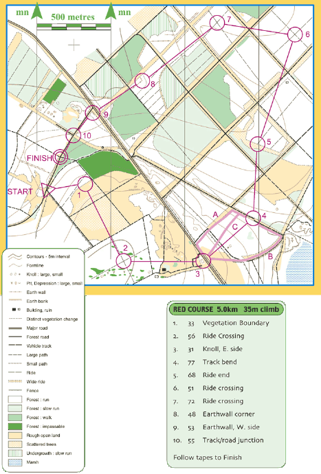
A sample orienteering map is shown above (taken from the British Orienteering website). This includes a typical orienteering course, a key of symbols (bottom left) and a list of descriptions of each of the control points (bottom right) – see below for more explanations of these.
The course on this map is a Red colour standard course. You will see that the Start is marked with a triangle, each of the control points are marked with a circle, and then the Finish point with a double circle. This notation is used for all orienteering courses (although most maps will not include the words “Start” or “Finish”, so remember that the Start is a triangle!). You will always be at the Start point when you pick up your map (this will be marked with an orienteering flag on the ground).
The course above has 10 controls to visit – note that you must visit the controls in the correct order, 1-10. The route you take between the controls is entirely up to you.
The control description sheet (see bottom right above) contains details of the control codes and a description of the location of the flag. For example, control number 1 has code 33 and is located at a vegetation boundary (i.e. the boundary between some forest and open land.) When you find the control with code number 33 you will know you have found control number 1 – “punch” it with your SI card, and move on to number 2!